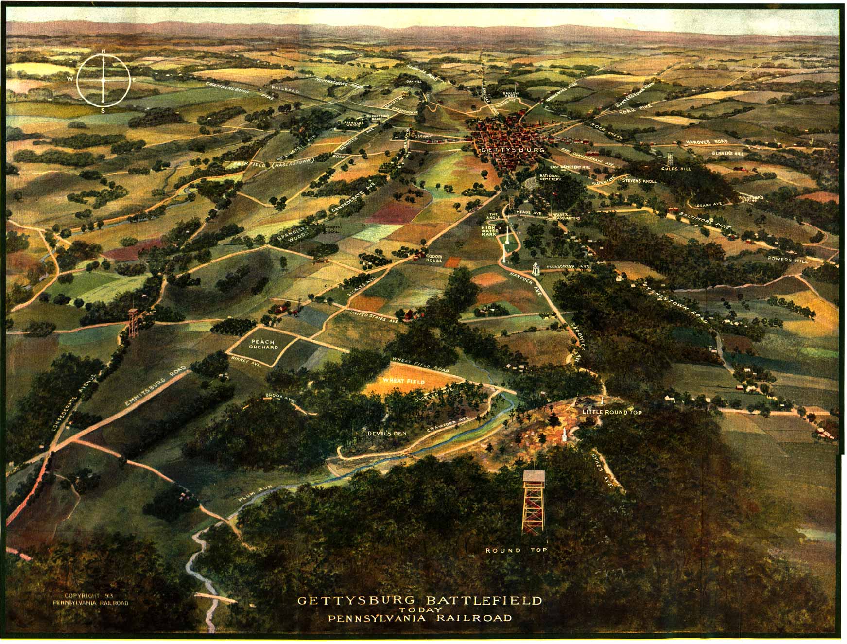
| The 1913 Pennsylvania Railroad map
easily rivals Bachelder's Isometric Drawing of the battlefield of Gettysburg,
in visual beauty, presentation, and in the amount of information conveyed
to the viewer.
The perspective of Bachelder's Isometric Drawing
is that of an observer "in a balloon suspended in air two miles east
of Gettysburg, looking west over the terrain." The Pennsylvania Railroad
map portrays the field in a similar fashion with the observer suspended
over the southern portion of the field, looking towards the north.
Perhaps the most impressive aspect of Map 4 is
the phenomenally detailed depiction of the battlefield as it existed at
the time of the 50th anniversary of the battle. The lack of encroachment
of woodland on the sight lines surrounding Plum Run and the Slyder farm
are a striking contrast to the field seen today.
So incredibly detailed is the pictorial representation
that monuments such as the portrait statues of Buford and Reynolds can
be seen on the first days field, as can the equestrian statues of Meade
near Ziegler's grove and Hancock on East Cemetery Hill. Landmarks and features
such as the Roger's House, Wentz house, Springs Hotel, Forney farm buildings,
the 5 War Dept observation towers, etc. which have passed from the modern
field can still be found on this time capsule drawing.
The map measures 163/4 x 211/2 inches. It was
scanned in 5 pieces and minor tears in the original were digitally repaired
prior to being assembled into the map shown here. The map is from the collection
of Terry Moyer.
Reference:
"John B. Bachelder: Government Historian of the Battle of Gettysburg",
Sauers, Richard A., Gettysburg Magazine #3, July 1, 1990, p 116.
Terry Moyer March 9, 2000 |
| Additional notes on the 1913 Pennsylvania
Railroad map:
From the Introduction to the Pennsylvania
Rail Road commemorative booklet
(page 5)
In commemoration
of the Fiftieth Anniversary of the Battle
of Gettysburg,
and for the especial benefit
of its patrons who will visit the battlefield
during the celebration
this year, the Pennsylvania Railroad issues this booklet, containing descriptive
matter, illustrations and maps.
Those consulting its pages,
will find a concise account of the movements
of the Union
and Confederate forces from the time
Lee moved northward from Virginia to occupy
the Pennsylvania valleys; the various engagements
in and around Gettysburg.
and a brief review of the retreat
of Lee across thePotomac
River, pursued by the victorious forces of Meade.
A birds-eye map of the battlefield,
on which the more important points of interest
and the principal roads and avenues are indicated, will be a guide to visitors.
A map of the Pennsylvania System shows its relation to
Gettysburg and the principal battlefields
of the Army of the Potomac and the
Army of Northern Virginia. Illustrations of various portions of the field
and the monuments thereon round out the booklet, which it is hoped will
serve to impress upon the mind the historic importance
of this noted battle and the field on which it was fought.
The unusually observant reader of this particular
example of the Pa RR map may be surprised to discover a hand-written notation
inscribed somewhere thereupon. Internal evidence in the booklet from which
this map was digitized indicates that it was probably purchased by a Southern
veteran on his way to attend the 50th anniversary reunion of
the Blue and Gray.
There are a number of photographs of the battlefield
inside the booklet. There is a small 'X' pencilled along side many, though
not all, of the photographs in the book. In one photo showing the 44th
NY monument on Little Round Top, a small 'x' appears along side of the
picture, with an additional 'x' written above the observation platform
of the monument. Another photograph taken from Hancock avenue near the
angle and looking south, has the notation 'Round Top' above the prominence
of Big Round Top in the photograph.
Another interesting comment can be found beside
the picture of Spangler's spring, stating: "Stopped here and ate supper
on tour of battlefield in busses". These annotations apparently represent
the sites taken in by the veteran as he visited the various points of interest
on the field.
So what information indicates that this person
was a southern veteran attending the reunion? The notation on the map is
this: "* camped here". There is also a photograph in the booklet entitled
'The round tops as seen from the Confederate lines'. This photo also contains
the notation "* camped here" written on the picture in such a way as to
correspond with the notation on the map. The location of the camp area
indicated is that part of the field that was reserved for the State of
Virginia during the 1913 anniversary reunion. |